2016年6月15日星期三

Avoid Altitude Sickness


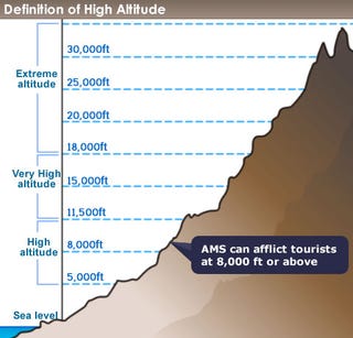
What is Altitude Sickness?

At over 3,000 meters (10,000 feet) 75% of people will have mild symptoms. The occurrence of AMS (Acute Mountain Sickness) is dependent upon the elevation, the rate of ascent, and
individual susceptibility. Many people will experience mild AMS during the acclimatization process. The symptoms usually start 12 to 24 hours after arrival at altitude and begin to decrease in severity around the third day.
The symptoms of Mild AMS include:
  1. Ÿ Breathlessness & Headache
  2. Ÿ Nausea & Dizziness
  3. Ÿ Loss of appetite
  4. Ÿ Fatigue
  5. Ÿ Shortness of breath
  6. Ÿ Disturbed sleep
  7. Ÿ General feeling of malaise
Almost every visitor is affected by the high altitude in Tibet. The reaction may vary from person to person. This has nothing to do with age or sex, but it does have to do with physical fitness. Most of the visitors get acclimatized to the high altitude by taking it easy for one or two days. All these symptoms can be potentially life-threatening conditions that may only be relieved by moving to a lower altitude; travelers should inform themselves about the symptoms so that they can recognize them. The high altitude and people’s reaction to it is one of the difficulties to travel to Tibet. But it is not as serious as you imagined if you know it and get prepared for it.

Prevention of Altitude Sickness

The major cause of altitude illnesses is going too high too fast. Given time, your body can adapt to the decrease in oxygen molecules at a specific altitude. This process is known as acclimatization and generally takes 1-3 days at that altitude. For example, if you hike to Yampachen at 4,300 meters, and spend several days at that altitude, your body acclimatizes to 4,300 meters. If you hike to EBC at 5,200 meters, your body has to acclimatize once again. A number of changes take place in the body to allow it to operate with decreased oxygen.
  1. Ÿ The depth of respiration increases.
  2. Ÿ Pressure in pulmonary arteries is increased, “forcing” blood into portions of the lung which are normally not used during sea level breathing.
  3. Ÿ The body produces more red blood cells to carry oxygen.
  4. Ÿ The body produces more of a particular enzyme that facilitates.
  5. Ÿ The release of oxygen from hemoglobin to the body tissues.
Acclimatization
  1. Ÿ Do not over-exert yourself or move higher for the first 24 hours.
  2. Ÿ If you go above 10,000 feet (3,048 meters), only increase your altitude by 1,000 feet (305 meters) per day and for every 3,000 feet (915 meters) of elevation gained, take a rest day.
  3. Ÿ “Climb high and sleep low.” This is the maxim used by climbers. You can climb more than 1,000 feet (305 meters) in a day as long as you come back down and sleep at a lower altitude.
  4. Ÿ If you begin to show symptoms of moderate altitude illness, don’t go higher until symptoms decrease (Don’t go up until symptoms go down).
  5. Ÿ If symptoms increase, go down, down, down!
  6. Ÿ Keep in mind that different people will acclimatize at different rates. Make sure all of your party is properly acclimatized before going higher.
  7. Ÿ Stay properly hydrated. Acclimatization is often accompanied by fluid loss, so you need to drink lots of fluids to remain properly hydrated (at least 3-4 quarts per day). Urine output should be copious and clear.
  8. ŸTake it easy; don’t over-exert yourself when you first get up to altitude. Light activity during the day is better than sleeping because respiration decreases during sleep, exacerbating the symptoms.
  9. Ÿ Avoid tobacco and alcohol and other depressant drugs including, barbiturates, tranquilizers, and sleeping pills. These depressants further decrease the respiratory drive during sleep resulting in a worsening of the symptoms.
  10. ŸEat a high carbohydrate diet (more than 70% of your calories from carbohydrates) while at altitude.
  11. Ÿ The acclimatization process is inhibited by dehydration, over-exertion, and alcohol and other depressant drugs.
Preventive MedicationsDiamox (Acetazolamide) allows you to breathe faster so that you metabolize more oxygen, thereby minimizing the symptoms caused by poor oxygenation. This is especially helpful at night when respiratory drive is decreased. Since it takes a while for Diamox to have an effect, it is advisable to start taking it 24 hours before you go to altitude and continue for at least five days at higher altitude. The recommendation of the Himalayan Rescue Association Medical Clinic is 125 mg. twice a day (morning and night). (The standard dose was 250 mg., but their research showed no difference for most people with the lower dose, although some individuals may need 250 mg.) Possible side effects include tingling of the lips and finger tips, blurring of vision, and alteration of taste. These side effects may be reduced with the 125 mg. dose. Side effects subside when the drug is stopped. Contact your physician for a prescription. Since Diamox is a sulfonamide drug, people who are allergic to sulfa drugs should not take Diamox. Diamox has also been known to cause severe allergic reactions to people with no previous history of Diamox or sulfa allergies.
Dexamethasone (a steroid) is a prescription drug that decreases brain and other swelling reversing the effects of AMS. Dosage is typically 4 mg twice a day for a few days starting with the ascent. This prevents most symptoms of altitude illness. It should be used with caution and only on the advice of a physician because of possible serious side effects. It may be combined with Diamox. No other medications have been proven valuable for preventing AMS.
Both Diamox and Dexamethasone are Western Medicine. You are recommended to consult your doctor for the prescription as they can have some serious side effects.
Tibetan Herbal Medicine-Hongjingtian and Gaoyuan’an are very good preventive and treatment effects for Altitude Sickness and AMS (Acute Mountain Sickness). Honjingtian and Gaoyuan’an (Rhodiola Eoccinea and Hippophae) may help sleep at high altitude and thus increase oxygenation at night. The two Tibetan Medicines can be quite effective in treating altitude sickness. But it also has one side effect: if you take the medicine, your alcohol resistance will be higher, i.e. you can drink more before you get drunk. In accordance with theories of modern medicine,” oxygen deficit is the mother of all sickness”. Highland Hongjingtian can better regulate oxygen deficit in the local parts of the internal organs of human beings, can increase the degree of blood oxygen saturation, generating self-cure immunity, and thereby enhance life vitality. In addition, Hongjingtian has also function of relieving alcoholism (more alcohol can be consumed when in taking this kind of beverage before or after).
The altitudes of different places in Tibet
PlaceAltitudePlaceAltitude
Lhasa3658 mNyingchi3000 m
12001 ft9843 ft
Nagqu4507 mTsedang3500 m
14787 ft11483 ft
Qamdo3205 mShigatse3836 m
10515 ft12585 ft
Damshung4200 mGyantse4040 m
13780 ft13255 ft
Pome2750 mTingri4300 m
9022 ft14108 ft
Amdo4800 mZayui2325 m
15748 ft7628 ft

Who’d better not come?

  1. Everyone should have more or less altitude symptoms. However, those who have the following symptoms may not come to Tibet
  2. Someone relating to tuberculosis, pneumonia, serious tracheitis, bronchitis
  3. People who suffer from high blood pressure and severe heart disease should seek medical advice before going to Tibet.
  4. Have already got a serious cold.

Health Considerations

Because of its high altitude, largely remote destinations, and semi-arid weather Tibet comprises a unique set of health concerns. You don’t need to worry about Malaria or odd strains of para-typhoid here, but you should certainly consider the sun and altitude.
We do not want to supplant advice from professionals and more complete suggestions available in guidebooks, so we suggest you consult appropriate sources before coming. Our trips our designed so you do not over-exert yourself in the first few days, and our guides are experienced and aware of the dangers of altitude sickness. There is preventative and symptomatic medication to help with the minor symptoms of altitude sickness (headaches, nausea) and we recommend that you bring some.
We also strongly suggest that you bring sunglasses, hat and sunscreen — Tibet is not the place to work on your tan. Further clothing and equipment depends on the type of trip you are doing here. We are happy to make suggestions or recommend published sources for more information on appropriate supplies.
If you want to know more,please click me.
GreatTibetTour.com is an online travel agency and group tibet travel operator, offering affordable Tibet tour,lhasa tibet,walking holidays, Trekking Tour,road trips,the largest low cost tour operator in Tibet and to make the dream of traveling to Tibet possible for everyone.We can also help you to get the tibet permit and provide many travel tips.

Nine Sacred Lakes in Tibet

Before you taking a tibet travel,you should know the nine sacred lakes in tibet.


1. Lake Namtso — Heavenly Lake

lake namtso
Location: 240 kilometers north of Lhasa
Namtso means ‘Heavenly Lake’ in Tibetan. The lake is 70 kilometers long from west to east and 30 kilometers wide from south to north, with an area of 1,940 square kilometers. It is the largest salt lake of Tibet and the second largest of China.
Namtso is the highest salt lake in the world at 4,718 meters (15,479 feet). According to historical literature, the lake is said to have descended from the sky to earth, and so it was called Namtso, i.e. Heavenly Lake. Herdsmen living near the lake say that the lake has such high elevation that it is like it is hanging in the air.
Nyenchen Tanglha (念青唐古拉山) is a mountain with perennially snow to the south. There is a plateau and hills to the north and west. It has a wide lake shore and grasslands all around. 
Namtso Lake is formed in the tertiary depression of the Himalayas, so it is a depression lake. The lake keeps receding, and several ancient lake shorelines have been left as evidence. The highest one is about 80 meters above the present water level.
A legend says Namtso is the daughter of the god Indra (the mythological king of the abode of the gods) and the wife of Nyenchen Tanglha (念青唐拉). The goddess of the lake has a cyan body, three eyes, and two hands, with an aquarium on her right hand and a mirror on her left. Her hair is raised in a high bun with the other hair falling on her back. She rides a blue dragon and is quite charming.
Recommended tour to Namtso: Essence Of Lhasa And Lake Namtso Tour

2. Basum Lake — Standing on the Sun Throne

basum lake
Location: Basum Lake is located 90 kilometers (56 miles) west of Kongpo Gymdo County in Nyingchi Prefecture, and 400 kilometers form Lhasa.
Basum Lake is the sacred lake of Nyingma (one of the Tibetan Buddhism schools), and one of the largest freshwater lakes of eastern Tibet. It is surrounded by mountains, and has a mild climate. The average elevation is 3,538 meters, and the length and width are 15 kilometers and 2.5 kilometers respectively. The depth of the lake is 166 meters. Basum means ‘Three Rock’ in Tibetan.

Getting There

From Lhasa drive for 33 kilometers along the Sichuan-Tibet highway to Dagtze County. It is 47 kilometers from Gandan Temple to Maizhokunggar County and Riduo Xiang Nian Cun (日多乡念村).
Then “climb” up Myra Pass (米拉山口), elevation 5,087 meters. Drive for another 211 kilometers to Gongbo'gyamda County (工布江达县), then towards Nyingchi (林芝县) for 61 kilometers to arrive at Bahe Zhen (巴河镇), which cannot be found on the map.
There you can find the road sign to Basum Scenic Area on the left exit as you exit the town. This is where you leave the Sichuan-Tibet Highway. After 44 kilometers is Basum Lake. 
The road conditions are good with all asphalted roads. The driver should be careful on the mountain road around Myra Pass (米拉山口), which is brimming with a great many sharp turns.

3. Tangra Yumco

Tangra Yumco (当惹雍错) is the largest sacred lake that Bon adherents believe in and worship. It is also the third largest lake in Tibet with an area of 1,400 square kilometers, a length of 70 kilometers and a width of 20 kilometers. Its elevation is over 4,600 meters. It is lurking on the wild and remote land in west Tibet.
The lake sits on a “No Man’s Land”. which has an area of more than 20,000 square kilometers, there is one person every 6 square kilometers. It is sometimes mentioned in folk tales and legends, though people seldom know much about them, and there is no mention of those who have been there.

A Legend

In an ancient arid age it is said the god of Daguo Mountain came to Duilong from Wenbu District (文布地区) to seek for superior Tibetan barley seed. His behavior irritated the local gods and they ran after him.
Having suffering from innumerable trials and hardships, there were only a few dozen seeds left. The god of Daguo Mountain planted them beside his wife Tangra Yumco carefully. Tangra Yumco watered them delicately with her breast milk and nurtured them delicately. When the fresh young green seedlings grew, this kind couple were greeted with the cheers and crying of the herdsmen. Subsequently the barley tsampa (青稞糌粑) of Wenbu has become the sweetest food in Tibet.

4. Lake Raksas Tal — the Devil Lake

Raksas Tal lies by the holy lake Manasarovar, on its west. The blue Devil Lake has an outline like a crescent moon. Manasarovar, however, is shaped like the sun. When Tibetans pay respects to the holy lakes they also worship Devil Lake because of their tolerant understanding and cheerful kindness.
The devil lake and holy lake are not far away from each other, and between them there is a waterway making them interlinked. However, the two lakes have absolutely different water quality: the water of the holy lake is clear and sweet, and that of Devil Lake is bitter and astringent.
Such polar opposites are plentiful in Buddhist symbolism, like the devil and Buddha mother hugging each other, which tells us the whole universe is of harmonious and unified spirit. The holy lake and the devil lake ripple mildly in the breeze without any complaint or sorrow. Only eternal waiting is what they have in common.

5. Manasarovar — the Mother of the Holy Lakes

In the eyes of the Tibetan, Ngari (in the west of Tibet) is the horizon of the sky. It is more than 2,000 kilometers from Lhasa, and is almost impossible to get to. Therefore Ngari is called the “ridge of the roof of the world”. This is the amazing place where Manasarovar  lies.
According to the Tibetan holy book Tripitaka, after nine mountains to the north of India there is a large snow mountain. Under the snow mountain is the origin of the four Asian rivers. The big snow mountain in the Buddhist scripture is the holyMt. Kailash and Manasarovar is the origin of the four Asian rivers. There is the Yarlung Zangbo River in the east, Kongqi River in the south, Sutlej River, and Sengge Zangbo(Lion River) in the north.
Manasarovar (玛旁雍错) means ‘invincible jasper’ in Tibetan.
Buddhists think that Manasarovar is the holiest lake, a gift that Shengledazun (the god who created the Buddhist doctrine, 胜乐大尊) gave to the world. Its holy water can wash off the sorrow and evilness at the bottom of the heart. It is also the oldest and holiest holy land of Buddhism, Hinduism, and Bonpo (苯教). Manasarovar is considered the perfect lake of the spirit, the real heaven of the universe, and the Shangri-La of the gods.
The elevation of Manasarovar is about 4,500 meters, and its depth is 77 meters. The perimeter of the lake is about 90 kilometers.

6. Lamu Nacuo — Goddess Skull Lake

Pelden Lhamo (班丹拉姆) is one of the Buddha Guardians in Tibetan Buddhism. The name means the lucky goddess (also called Jetsunma Ahkon Lhamo, 吉祥天母). Lamu Nacuo (拉母那错) is shaped like a skull, so Tibetans believe the lake is formed by the melting of the goddess. The lake is the place on which the soul and spirit of the goddess are said to rest.
Standing in the remote mountains, with an elevation level with the snow line, she is little known by people. Far fewer people are lucky enough to get there to pay their respects.
Seen as the holiest revelatory lake in Tibet, the status of Lamu Nacuo has never been shaken through hundreds of years of disputes. Whenever the Dalai Lama or Panchen Lama passes away, Buddhists go to Lamu Nacuo to receive revelation, so as to get the most direct and realest picture before finding out the reincarnated soul boy. For example, they search for revelation about the mountains and rivers and the villages and houses of the boy’s home, and even his appearance and behavior in his childhood. People who walk around the lake and leave treasures are said to be able to see a Lama's previous and future life.
Lanmu Nacuo is so amazing, with her quiet, plain, and kind appearance.

7. Yamdrok Lake— the Turquoise Earring Scattered

yandrokyumtso lake
When standing on the top of Mount Baalah, rather than Yamdrok Lake, you may first see the peak of Noijinkangsang ising from the mountains, but you certainly can not ignore its existence for long.
Yamdrok Lake is called the most beautiful water in the world. The Tibetan means ‘green jade lake on the pasture’. It is regarded as the turquoise earring that a goddess scattered before the eyes of the Tibetans.
From whatever angle you look you are not able to see the complete lake. She has three sisters — Kongmucuo (空母错), Chencuo (沉错) and Bajiucuo (巴久错). The three lakes, in addition to Yamdrok Lake, are linked hand in hand, foot by foot, to form the boundless holy lake beyond our eyes. She wings among the mountains for over 130 kilometers. Only on a map can you surprisingly find that she is like an earring affixed to an ear-like mountain range. As the sun shines on Yamdrok Lake at different times she will appear dreamy blue with rich spectral levels.
One of the wonders of Yamdrok Lake is that the water originates from the snow water of Nyenchen Tanglha. However, despite there being no outflow, there is no change in the water level at all. The influent snow water and the natural evaporation have an amazing dynamic balance.
Recommended tour to Lake Yamdrok: 5-Day Lhasa tibet and Yomdrok Lake Tour

8. Siling Lake — the "Ghost" Lake Where the Big Devil Perches

Siling Lake is on the south of Qiangtang Plateau, with an elevation of 4,530 meters. It is 72 kilometers long from west to east, and 22.8 kilometers wide on average. The widest eastern part is 40 kilometers wide. Its area is 1,640 square kilometers, and it is the largest lake in Tibet.
Siling is the big devil who used to live west of Lhasa tibet. He was always swallowing thousands of living creatures including beasts and men. Everyone felt troubled by him. 
On a morning, after a heavy storm, Padmasambhava (莲花生大师, the creator of the Tibetan religion Red Sangha), who had been slaying demons, finally found Siling. Unable to repel Padmasambhava, Siling fled to a vast muddy lake on the south of Gangni Qiangtang (冈尼羌塘). Padmasambhava commanded him to stay in the lake and never to leave it, and not to kill the creatures in the water. Subsequently the lake was named Siling Lake.

9. Locally Famous Pangong Tso Lake

Pangong Tso Lake is located north of Ngari in the west of Tibet. Though it doesn’t have a peculiar and sacred religious significance, it is well known by local people. 
The lake is long and its western end is in Kashmir, where it is a salt water lake with little animal or plant life. Its middle and east part is freshwater, and there are abundant fish and waterweeds.

Tailor Make Your Tour to The Lakes

If you are interesed in travelling to one of the lakes above, you can tailor-make your own unique tour by telling us your interests and requirements. We will help you design a perfect trip.

2016年6月6日星期一

Geography and History in Tibet

In geological terms, the creation of the Himalayas and the rising of the Tibetan plateau are extremely recent events. The mountains originated less than four million years ago, making them among the youngest in the world.
About 80 million years ago India broke away from an early massive proto continent. Slowly and steadily it moved across the ancient Sea of Tethys, collecting hard sheets of rock along the way. Eventually it rammed into the soft underside of Asia, which the rock easily penetrated and pushed up, creating the Himalayas. From sea level these mountains rose rapidly to a height of nearly 9,000 metres (30,000 feet). Today the succession of parallel ranges, running east to west for nearly 3,200 kilometres (2000 miles), reveals this original plate boundary between India and Asia. In fact, the movement of sub-continental India is still forcing the Himalayas upwards at a rate of two centimetres (0.8 inches) per year in places.
 
The rivers of Tibet existed before the collision of India and Asia. As the soft sedimentary rocks that formed the bottom of the sea of Tethys were folded up, the rivers were able to cut through them and maintain their original north-to-south course. ( The Yarlong Tsangpo River is a major exception.) As a result there are many spectacular gorges and mountain ranges sliced up into individual massifs.
Much of Tibet, once well-forested, lush and fertile, is today one of the world’s most terrifying unforgiving places. As the Himalayas increased in height, less and less moisture reached the areas north of the range. The result has been a slow botanical death to the great northern plateau, the desertification of huge regions of Tibet and Xinjiang.
 
There are three distinct geographical regions in Greater Tibet. By far the largest natural region is the northern plateau, or Chang Tang, an enormous expanse of over a million square kilometres (386,000 square miles). It covers about half of Tibet’s total surface area and is delineated in the west by the great Karakoram Range, in the north by the wall of the Asia Tagh, and in the northeast by the Nam Shan Range. The Chang Tang has one of the worst climates on earth, with strong winds every day and bitterly cold temperatures throughout the year. There is little rainfall and outlet for the rivers. As a result, the region is characterized by myriad salty and brackish lakes.
 
These factors-constant wind, low rainfall and salt in the soil-severely limit the types of plant life that can survive, these being mostly grasses and herbs. There are fewer than 60 species of flowering plants, only three of which are woody.
 
One outstanding feature of the Chang Tang is the Zaidam or salt marsh in the north. It used to be an enormous salt lake, which has now mostly dried up but retains some marshy areas. The Zaidam is distinguished by its large numbers of waterfowl and waders; more than 200 species of birds have been identified there.
 
It would be noted that most of the Chang Tang is never visited by humans. The hunters and nomads who live permanently on the Northern Plateau generally confine their wanderings to the southern and eastern parts of that great wilderness.
 
The second main geographical region of Tibet, the outer plateau, extends in a great arc for nearly 3, 500 kilometres ( 2,200 miles) from Baltistan in the west to beyond Xining, the capital of Qinghai, in the east. It is a relatively narrow strip, with the Himalayas forming the southern boundary. It is the most populous part of Tibet and contains almost all the major human settlements.
The outer plateau differs from the northern plateau in several important ways. First, the temperature and climate are milder, and consequently there is a richer distribution of flora and fauna. Secondly, agriculture exists in the outer plateau in many old and well-developed agricultural regions. The area around Shigatse and the Lhasa Valley are clear examples of this. Countrary to popular images of Tibet, Lhasa has a pleasant climate, with nearly all its rainfall occurring in the summer. For most of the year the weather is sunny and dry, mild during the day from April to October, and not unbearably cold in winter.
 
In the west, the outer plateau is an expanse of gravelly land, where vegetation is poor, but in the east it becomes a grassy steppe, running all the way to the yellow river, where there is more rainfall, warmer weather and significantly more vegetation.
 
The other main geographical region is the southern plateau or ‘river gorge country’, comprising only one- tenth of the total area of Tibet. Plant and animal life here is vastly richer than in the other regions. Forests are very much a characteristic of the southeastern plateau; its western and northern boundaries follow the natural limits of trees.
 
The transition from the outer plateau to the southeastern plateau is gradual, though marked by a steady increase in trees and decline in altitude. The lowest point in Tibet-1,615 metes (5,297 feet)- is near the great bend of the Yarlong Tsangpo river as it turns southward towards India. This region has an abundance of alpine and tropical plants such as laurel, rhododentron, azalea, bamboo, magnolia, oak, and even tea and banana, most of which appear in or near dense, moist evergreen forests.
 
The most dramatic geographical phenomena here are deep river gorges formed by the upper reaches of the Salween, the Mekong and the Yangzi, three of Asia’s mightiest rivers. These orges erode and dissect the land, allowing moisture bearing winds of the summer monsoon to reach the southeastern plateau.
Many animal groups are impoverished by the high altitude and severe climate of Tibet. There are very few amphibians or reptiles- or  insects, limiting the number of insectivorous birds ( fly-catchers,  swallows, swifts) , moles and shrews. Fish  are generally members of the salmon and carp family. They abound in rivers and some lage lakes, such as Namtso, but many lakes have so much salt that no fish at all can survive.
 
Most of the animals of the northern and outer plateau are desert and steppe species. These animals-particularly the hooved variety- are well adapted to the harsh conditions and wide open landscapes, which require them to migrate long distances in search of food.
 
The shaggy, powerful yak is a shining example of animal adaptation to the awful demands of Tibet. Another typical animal is the kiang, or wild ass. It often gathers in large herds, especially in western Tibet, and makes extremely long journeys in search of pasture. The Kiang is the fastest runner on the plateau. Another remarkable and very beautiful beast is the Tibetan antelope, outstanding for its long, thin, almost vertical horns, which can attain 70 centimetres ( 28 inches) in length.
 
The most numerous mammals in Tibet are rodents, which are ubiquitous wherever there is sufficient plant material to support them. Predators such as wolves, foxes and bears rely to a large extent on these rodents. Another predator, and perhaps the most magnificent of all Tibet’s creatures, is the extremely rare snow leopard.
More than 500 species of birds have been recorded in Tibet, and even the most casual observer can easily identify 20 or 30 separate varieties. This number can quickly be doubled with a bit of careful study or just a visit to one of Tibet’s great lakes.

2016年6月3日星期五

Tibet Trekking Tour

Why do trekking in Tibet 
Tibet, land of spirit and dream, is always mysterious to trekkers. Lying in the shadow of Himalaya, the breathtaking high plateau landscape of Tibet offers great opportunities for trekker. No matter what your interest is, let’s say climbing majestic towering mountains, circling around holy lakes, visiting sacred monasteries, riding horses across the vast grasslands, or hiking through national parks, Tibet has something for you.

Trekking is a perfect way to explore Tibet and a wonderful experience of a lifetime that you can’t get anywhere else on earth. By trekking in Tibet, you can enjoy the unique landscapes on the roof of the world and have a full insight of Tibetan culture. You can sense the subtle and harmonious relationship of people with nature once you step on the highland.
What to do and see while trekking 
Here are several recommended trekking tour routes in Tibet which offer you breathtaking views and unforgettable experiences. Most importantly, the routes are accessible to all levels of skills and experience.Gandan to Samye trek is the best long trek, which costs you 4 to 5 days. You will traverse two passes over 5000m that are Shuga-La pass and Chitu-La pass. You can see holy lakes, beautiful alpine landscapes, nomads’camps, sacred sites, as well as two of Tibet’s greatest centres of religious culture-Gandan monastery and Samye monastery.

The best short trek is Shalu to Nartang trek with 2 to 3 days. This trek follows the ancient trade route between two great Buddhist monasteries and you can feel the caravans laden with scriptures and treasures that once passed this way. The route passes through several villages as well as uninhabited dry canyons, while the trails are easily accessible from Shigatse.

Mount Kailash trek is one of the most demanding and challenging treks for pilgrims in the world, which is widely known as the kora around Asia’s holiest mountain-Mt. Kailash. This trek admirably integrates the spiritual, cultural and physical dimensions of a trip in Tibet. You can see some gorgeous mountain scenery along the way and meet some pilgrims from Tibet and other countries.

Tsurphu to Yangpachen trek begins at Tsurphu Monastery and crosses several high valleys before coming into the broad and windswept Yanpachen valley. It combines alpine tundra, monasteries, hot springs, lots of nomads, and remote nunnery. This trek perfectly balances cultural and wilderness activities. It’s an excellent choice if you want to get a close look at the lifestyle of the herders.

Nyenchen Tanglha Traverse trek is incredible for you to see ecological diversity of northern Tibet. The route leaves Damxung Valley and wends its way through a rocky alley, and a number of stream crossings aside you. You will pass through gorges, alpine meadows and forested slopes. Fantastic views of sparkling Nam-tso and Tashi Do can be visible from many vantage points on the trail. Some colorful nomad camps dot the way as well.

Everest base camp to Tingri trek provides a complex mix of solitude, wildlife sighting and physical challenge. It is an excellent alpine trekking in the shadow of the legendary Mt. Everest. On the way to Everest Base Camp, you will have enough time to explore the valleys and glaciers below the massive north-face of Mt. Everest and view the most magnificent scenery on the world's highest mountain. You can also see much wild wildlife in the valleys and pasture along the way.
When to go
All seasons are perfect for trekking tour except snowy (Nov-March) seasons. Generally, the ideal time for trekking in Tibet is from April to October. April to June and September to October are most highly recommended months without much rain or snowfall. During the snowfall, not only the mountains are inaccessible but the highways that take you to the trail heads are blocked. July and August are the hottest months of the year and the rainy season in Tibet. The roads are in bad conditions which make your trekking messy and hard.

GreatTibetTour.com is an online travel agency and group tibet travel operator, offering affordable Tibet tour,the largest low cost tour operator in Tibet and to make the dream of  traveling to Tibet possible for everyone.

Lhasa: How to apply for Tibet permit 2016

Since the policy on Tibet travel permit 2014 removes the restriction on group size and nationality, all travelers can easily get Tibet permit 2014. Now you can follow the following steps to apply for a Tibet permit to make you dream of travel to Tibet become true.
Firstly, obtain a Chinese visa from a Chinese Embassy in your home country. To apply for a Tibet permit 2013, you need to email the scanned copy of your Chinese visa and passport to a licensed Tibet travel agency. All individuals entering China must hold a passport that is valid for at least six months for a single or double entry visa and at least nine months for a multiple entry visa. This should also be the first step of travel to Tibet.
Secondly, design your Tibet tour route because you need to mention where you will go in Tibet when applying for the Tibet permit. For example, you plan to make a Lhasa tour by train from Xining to Lhasa and then to Xining by flight. Your travel route stated on the Tibet permit is Xining-Lhasa-Xining. If you plan is taking the Beijing to Lhasa train to Tibet, and then travelling from Lhasa to Kathmandu visa Gyantse, Shigatse and Everest Base Camp, your travel route stated on the Tibet permit is Beijing, Lhasa, Gyantse, Shigatse, EBC, Kathmandu.


Thirdly, find a Tibet tour operator online to apply for Tibet permit for you as the Tibet permit must be applied for through an authorized travel agency. There are dozens of Tibet travel agencies offering Tibet tours for your choice. It is important to choose a reliable and professional Tibet travel agency, which will guarantee you an impressive Tibet tour. Besides, not all travel agencies can help you get Tibet permit in 2013. Only large Tibet travel agencies are able to obtain Tibet travel permit for travelers.
After confirming which Tibet travel agency you will use, you need to email a scanned copy of your Chinese Visa and Passport to that agency so that they can apply for the Tibet permit for you. What you should do next is waiting for your Tibet permit. The travel agency usually will send your Tibet permit to your reserved hotel in China or have someone to meet you at the airport and give you the permit.
At the same time, you should begin to prepare for your trip to Tibet, such as book air tickets or train tickets to Tibet. Usually, you can get a little discount on air ticket if you book in advance. If you want to enjoy the world’s highest railway, the Qinghai-Tibet Railway, it is best to book the train tickets at least one month in advance because it is a hot tourist railway and it is difficult to get a ticket sometimes. But only travel agencies with annual booking from the train ticket office can book train tickets one month in advance, so it is wise to ask an online travel agency to book the train tickets for you.

2016年5月25日星期三

Tibetan Butter Sculptures — Tsepdro — for Losar


The making of tsepdro — the kind of Tibetan butter sculpture commonly created at Losar (Tibetan New Year) — is one of the most unusual and beautiful sacred arts of Tibet. We visited the Gyuto Foundation in Richmond, California last weekend to see the local monks creating the delicate, wildly colorful designs made of butter. 
The most popular designs for the butter sculptures are:
  • flowers
  • tashi dargye: the 8 auspicious symbols
  • norbu kagyi: the precious jewel
  • thunpa punshi: the 4 harmonious friends (elephant, monkey, rabbit and bird)
  • tsering drukor: the 6 elements representing longevity: an old man, river, crane, deer, tree, cliff
  • nyima dawa: the sun and moon
Continue reading below the photo gallery… 
The designs are usually constructed on a flat piece of wood in the shape you see here, and placed in piles of tsampa and chemar in a chemar bo, which is a special carved wooden box used on shrines at Losar. (Learn more about thechemar bo in this post on creating a Losar shrine.)
Traditionally, the butter sculptures are made of dri butter (dri is the female of the yak species), but the Gyuto monks have found a kind of butter from Australia that doesn’t melt as easily as normal butter. Usually the monks who make the tsepdro have to constantly dip their fingers and the butter they are working with in icy water to keep it from melting.

Medical Uses for Nandrolone Decanoate

Overview
Nandrolone decanoate is a man-made steroid hormone with a physical structure similar to the male sex hormone testosterone. The drug is administered as a deep intramuscular injection. After absorption into the bloodstream, the drug travels to the muscles and other body tissues, exerting testosterone-like effects. Due to serious and potentially life-threatening side effects, the medical uses for nandrolone decanoate prove limited.
Anemia of Renal Insufficiency
The kidneys normally produce the hormone erythropoietin, which stimulates the production of red blood cells in the bone marrow. People with chronic kidney disease often experience anemia, or a low red blood cell count, caused by inadequate production of erythropoietin. Therapy with nandrolone decanoate may help alleviate this condition, known as anemia of renal insufficiency.
Nandrolone decanoate may stimulate the production of erythropoietin, leading to increased red blood cell production, explains the National Cancer Institute. In an October 2005 article published in the “European Journal of Clinical Investigation,” Drs. Robert Deicher and Walter Hörl report that use ofnandrolone decanoateproves beneficial for some male patients with anemia of renal insufficiency. The authors, however, advise against using the drug for female patients due to side effects. Among female patients, nandrolone decanoate may cause masculinizing side effects, such as increased body hair, disruption of the menstrual cycle, deepening of the voice and male-pattern hair loss.
Treatment of anemia of renal insufficiency is the only U.S. Food and Drug Administration-approved use of nandrolone decanoate, according to the National Library of Medicine pharmaceutical information website DailyMed.
HIV-Associated Wasting
Patients with advanced HIV/AIDS may experience significant weight loss, including loss of muscle mass. The Centers for Disease Control and Prevention includes this condition, known as HIV-associated wasting, as evidence of HIV disease progression to AIDS. Doctors sometimes prescribe nandrolone decanoate to help arrest or partially reverse HIV-associated wasting. Kathleen Mulligan, Ph.D., and Dr. Morris Schambelan of the University of California, San Francisco report on the website HIV InSite that nandrolone decanoate may help patients with HIV-associated wasting gain body weight and muscle mass. These beneficial effects prove most pronounced in patients participating in an exercise program while taking nandrolone decanoate.